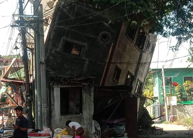
Safety is the top priority or homeowners in situating the home that you are about to build. In the past couple of years, there were threats of “the big one” happening across the West Valley Fault. If this happens, it could affect major areas in Metro Manila.
The Department of Science and Technology’s National Research Council of the Philippines states that the “big one” could generate a 7.2-magnitude earthquake. This will cause devastation through most of the progressive parts of Metro Manila.
The “big one” will run through the West Valley Fault that traverses through major Metro Manila areas, including Makati, Taguig, Muntinlupa, Paranaque, Quezon City, Pasig, and Marikina. It will also affect the nearby provinces of Bulacan, Cavite, Rizal, and Laguna. According to PHIVOLCS, the West Valley Fault moves every 200 to 400 years; its last recorded movement was in 1658. As of 2022, this was 364 years ago, alluding that the threat of the “big one” might be larger than before.
Homeowners should know and understand how important the location is when they decide to build their houses. Fault mapping can be helpful to homeowners, so they can place their houses in better locations at lower risk.
Understanding Where to Build Your Homes
Homeowners and companies need to consider a couple of factors when deciding on a place to build houses and developments. Apart from identifying fault lines and fault mapping, there are other factors to understand before selecting a location:
- Topography
- Geology
- Location
- Availability of services
- Lifestyle
- Over-all vibe of the area
- Local Climate
- Neighorhood
- Transportation and Accessibility
- Noise
Beyond that, it helps to know whether the location of the home that you are looking to build is near a fault line or not. Therefore, learning about the fault lines in the Philippines is important. This will help homeowners and companies in taking precautions, so that the structures built can withstand an earthquake without incurring too much damage.
READ MORE: Earthquake Safety: 5 Ways to Build an Earthquake-Resistant Structure
Fault Mapping: Explaining Fault Lines in the Philippines
Fault Mapping starts with knowing the major fault lines. The Philippines is along the Pacific Ring of Fire, making it more vulnerable to earthquakes and volcanic eruptions.
Understanding fault lines in the Philippines can help homeowners and construction companies alike decide where to build homes and developments. Building near fault lines can endanger people and establishments – especially during an earthquake. Here are some of the major fault lines in the Philippines to know about:
Marikina Valley Fault System
The Marikina Valley Fault System is one of the most dangerous fault systems. This system passes through the busiest and major areas of Manila and it is the most seismically active fault line in the country. In the event of the “big one”, the Marikina Valley Fault System may cause Taal Volcano to erupt because of the shifting in the fault line.
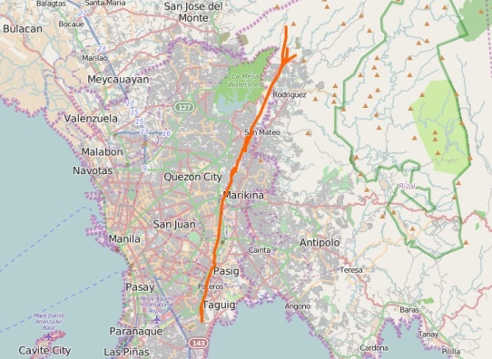
The East and West Valley Fault Lines are part of the Marikina Valley Fault System, traversing through:
- Makati
- Taguig
- Muntinlupa
- Paranaque
- Quezon City
- Pasig
- Marikina
- Biñan
- Calamba
- Carmona
- Montalban
- San Matero
- San Pedro
- Santa Rosa
- Tagaytay
- Oriental Mindoro
Central Philippine Fault Zone
The Central Philippine Fault Zone is like the Marikina Valley Fault System that traverses through various provinces and cities from the northern portion of the archipelago down to the northern part of Davao. Notably, the Central Philippine Fault Zone is also responsible for the slow slide occurrences’ fault creep, and big earthquakes on the opposite end of the spectrum.
The Central Philippine Fault Zone has fault lines in the following areas:
- The entirety of Ilocos Norte
- Aurora
- Quezon
- Agusan del Norte
- Agusan del Sur
- Eastern Leyte
- Southern Leyte
- Davao del Norte
The Central Philippine Fault Zone caused the Guinsaugon Earthquake and the 1990 earthquake that devastated Central Luzon and Baguio City.
Eastern and Western Philippine Fault Lines
There are also earthquakes that are caused by the water level – such is the case of the Western and Eastern Philippine Fault Lines that run across the seas in the west and east regions of the Philippines.
We can find the Eastern and Western Philippine Fault Lines in the following locations:
- Philippine Sea
- Luzon Sea
- Mindoro Strait
- Panay Gulf
- Sulu Sea
Southern Mindanao Fault Lines
The Mindanao Fault is across the Celebes Sea and the Moro Gulf – not within the provinces or cities of the region. Regardless, the Southern Mindanao Fault Lines pose a lesser threat to people because a larger part of it is in the sea. However, if one of the fault lines shift, it will put the entire region in jeopardy – it shouldn’t be taken likely, either.
Guinayangan Fault
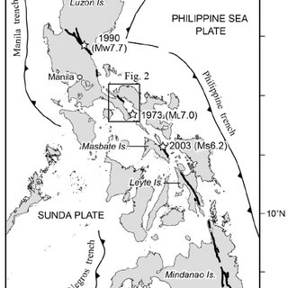
The Guinayangan Fault, according to 2020 data from PHIVOLCS, is an active fault traversing through the central portion of Quezon Province. It can generate high-intensity earthquakes, as seen during the magnitude 7 Ragay Gulf Earthquake that happened in 1973.
Masbate Fault
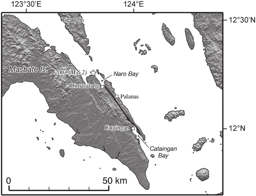
Another seismically active fault in the country is the Masbate Fault, causing frequent quakes in the area. Apart from the Masbate Fault, there are other potentially active faults in the area, including the Uson Fault and the Southern Masbate Fault. In 2022, a magnitude 6.6 earthquake struck the Masbate province and devastated the nearby provinces of Albay, Biliran, Aklan, Leyte, Capiz, and Negros Occidental.
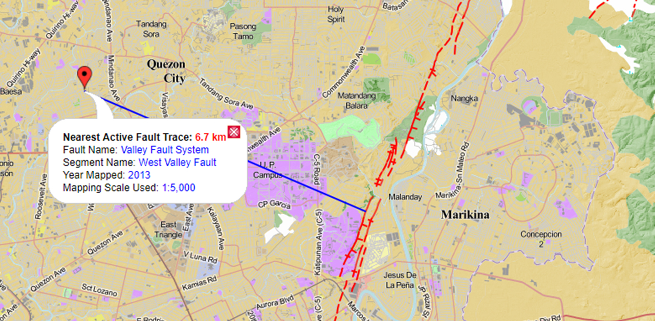
PHIVOLCS FaultFinder: Locating Faults Easier
Because there are a couple of fault lines that pose a threat to cities and provinces across the country, PHIVOLCS created a web application that would provide proximity searches to discover active faults. Apart from that, it can also measure the shortest distance between the said fault and the user or a specific site.
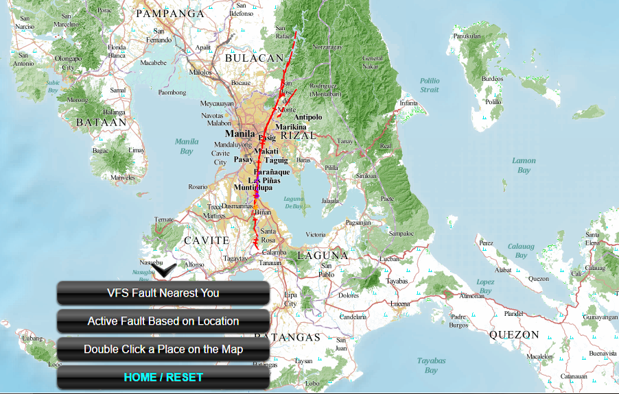
The PHIVOLCS FaultFinder also lets you use three base maps: the Philippines Geoportal, Google Maps, and Openstreet. With these maps, the application can give users information that includes the fault name, segment name, map scale, year of mapping, and the user’s distance to it. It also shows the location of active faults in the Greater Metro Manila Area and other fault systems. The app also helps with land-use planning, awareness, risk assessment, and in creating a disaster risk reduction plan.
PHIVOLCS, Department of Science and Technology, Geological Survey of Japan, and Japan’s National Institute of Advanced Industrial Science and Technology created the PHIVOLCS FaultFinder. It was developed by Dr. Joel Bandibas of GSJ, with the cooperation of PHIVOLCS.
READ MORE: Better Safe Than Sorry: Building a Disaster-Proof House on a Budget
Always remember that prevention and preparedness are always key to making sure that any houses or establishments and the people within it are safe during the event of an earthquake. Since more houses, developments, and condominiums are being built – with some of them being near fault lines – it’s essential that homeowners and companies are aware of any fault lines near their location so that they can adequately prepare for earthquakes that may come.
Do you want to see more content like this in the future? Subscribe to Pinoy Builders for FREE today and stay in the loop for the latest news and updates on the Philippine construction industry!
Sources:
- What is West Valley Fault Line: All You Need to Know About the Big One (Metro Manila & GMA Earthquake). (2022, July 28). It’s More Fun with Juan. https://www.morefunwithjuan.com/2022/07/west-valley-fault-line.html
- Joselito Alonte Carteciano. (2017, August 2). THE BIG ONE Part 2. NRCP. https://nrcp.dost.gov.ph/feature-articles/279-the-big-one-part-2
- PHIVOLCS Staff. (2012). The PHIVOLCS FaultFinder. Dost.gov.ph. https://www.phivolcs.dost.gov.ph/index.php/information-tool/the-phivolcs-faultfinder
- PHIVOLCS Staff. (2013). Philippine Fault Zone Maps. Dost.gov.ph. https://www.phivolcs.dost.gov.ph/index.php/2-uncategorised/635-philippine-fault-zone-maps
- Staff, P. (n.d.). DOST-PHIVOLCS URGES PUBLIC TO PREPARE FOR “THE BIG ONE.” Www.phivolcs.dost.gov.ph. https://www.phivolcs.dost.gov.ph/index.php/news/8542-dost-phvolcs-urges-public-awareness-to-prepare-for-the-big-one
- List of Fault Lines in the Philippines. (2022, July 27). Lumina Homes. https://www.lumina.com.ph/news-and-blogs/blogs/fault-lines-in-the-philippines-list/
- Almaden, J. (2013, October 17). How Safe Are You and Your Property From Earthquake Fault Lines? PhilPropertyExpert.com. https://philpropertyexpert.com/how-safe-are-you-and-your-property-from-earthquake-fault-lines/
- Choosing and using a site | YourHome. (n.d.). Www.yourhome.gov.au. https://www.yourhome.gov.au/buy-build-renovate/choosing-site
- Media, A. I. (2018, March 1). Site Yourself. Loghome.com. https://www.loghome.com/articles/Choosing-a-House-Site-How-to-Pick-the-Best-Possible-Spot-to-Build


